
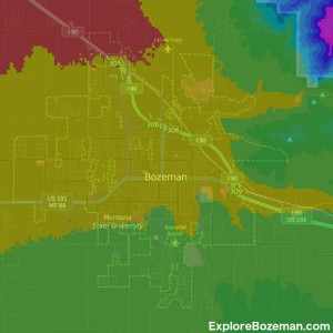
 The elevation in Bozeman is 4,820 ft (1,461 m) on average. Bozeman, MT is located in Gallatin Valley, which as the name suggests is a valley surrounded by mountains. While the valley floor is relatively flat, there is some elevation change.
Bozeman Elevation
The southeast corner of town is the highest at roughly 5,000 ft (1,524 m) in elevation. The northwest corner of Bozeman is the lowest in elevation at approximately 4,600 ft (1,402 m) elevation. Towns west of Bozeman are lower in elevation. Belgrade is 4,500 ft (1,371 m). Manhattan is 4,200 ft (1,280 m). Three Forks is 4,100 ft (1,250 m). To the east of Bozeman is the Bozeman Pass. The elevation of Bozeman Pass is 5,702 ft (1,738 m). Bozeman Pass is situated approximately 13 miles (21 km) east of Bozeman, Montana and approximately 15 miles (24 km) west of Livingston, Montana on Interstate 90. It separates the Bridger and Gallatin mountain ranges. The elevation of Livingston is 4,500 ft (1,372 m). Big Sky ranges from 6,000 ft (1,829 m)in the canyon to 8,000 ft (2,438 m) in Mountain Village. The elevation of West Yellowstone is 6,600 ft (2,012 m).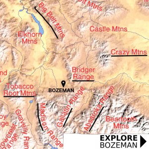 The 6 mountain ranges surrounding Bozeman have numerous peaks over 9,000 ft (2,743 m).
Bridger Range
The Bridger Mountains are located to the northeast of Bozeman. The Bridger Range is approximately 45 miles (43 km) in length. The highest peak in the Bridger Range is Sacagawea Peak at 9,665 ft (2,496 m).Gallatin Range
The Gallatin Range is located south of Bozeman and includes more than 10 mountains over 10,000 feet (3,000 m). The highest peak in the range is Electric Peak at 10,969 feet (3,343 m).Madison Range
The Madison Range is located southwest of Bozeman. The Madison Range of mountains are 45 miles long, and have a thick area of rugged peaks and rolling uplands that lie between the northwestern boundary of Yellowstone National Park to the east, the Madison River Valley on the west, and Big Sky and Bozeman to the northeast. The highest peak in the Madison Range is also the highest peak in Montana outside the Beartooth Range. Hilgard Peak measures at 11,316 feet.Crazy Mountains
The Crazy Mountains, often called the Crazies, are the most dramatic mountains in the area. Spanning a distance of 40 miles (64 km), the Crazy Mountains are located between the Musselshell and Yellowstone rivers. The highest peak is Crazy Peak at 11,214 feet (3,418 m). The Crazy Mountains rise 7,000 feet above the Yellowstone River Valley and the surrounding plains east of Bozeman.Absarokas
The Absarokas are located southeast of Bozeman. The range stretches about 150 mi (240 km) across the Montana-Wyoming border, and 75 miles at its widest, forming the eastern boundary of Yellowstone National Park along Paradise Valley (Montana). Eight peaks in the Absaroka Mountains exceed 12,000 feet, including the highest point, Francs Peak (13,140 feet) located in Wyoming.Tobacco Roots
The Tobacco Root Mountains lie in the northern Rocky Mountains, between the Jefferson and Madison Rivers in southwest Montana. The highest peak is Hollowtop at 10,604 feet The range contains 43 peaks rising to elevations greater than 10,000 feet.Category : Information